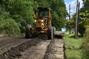
Township road crew member Matt O’Dell grades the dirt portion of Meek Street in preparation for applying asphalt road grindings.
Brookfield Township officials have released a plan for paving township roads over the next 20 years as part of a request that township voters approve a 3.5-mill, continuous levy for the roads on Nov. 8.
Officials have said they plan to use the money for paving and any related drainage work they have to do when they pave a road, although they cannot legally limit use of the the money in this way.
The township generally has used an allocation from the general fund each year for paving, and that allocation has been used as a local match to apply for Issue 1 funds. Issue 1 is a state bond-funded program to help pay for infrastructure projects. Road Supt. Jaime Fredenburg said he expects to use levy proceeds for a local match for Issue 1 grants and any other grants that are out there.
“We apply for those every year because it’s such a nice way to leverage money,” he said. “You can double your money.”
The levy money also could be used to pay off loans if the trustees decide to borrow money to accelerate the paving process, he said.

The road plan is based on current paving costs and adds 2 percent for inflation each year. Roads could be moved up on the list if grant money becomes available, or moved back if the township runs out of the money available in a particular year, Fredenburg said.
The plan includes paving the dirt sections of accepted roads, including parts of Addison and Amy Boyle roads.
Although they are not specifically set in the plan, officials also want to pave unaccepted roads, bringing them up to county specifications so they will become accepted for township maintenance.
“I haven’t completely nailed down with the trustees as far as the unaccepted roads,” Fredenburg said. “Their plan, I think, is to at least try to get one unaccepted road in each year. They still have to iron out the process.”
At this point, there is no intention to use the money to install curbs or paint lines, he said.
The plan does not take into account roads that are owned by Trumbull County or the state of Ohio. However, some roads, such as Albright McKay, have a portion that is owned by the county and another portion owned by the township. The township sections are part of the plan.
@@@
The following is Brookfield’s 20-year plan for the paving of township roads, should a 3.5-mill levy be passed by voters in November:
2023
King Graves Road (half), Albright McKay Road (between King Graves and Amy Boyle Road), Lucy Street, Jane Street, Edmond Street, Erie Street, Jacqueline Drive and North Stateline Road.
2024
Valley View Drive, Wildwood Drive, Golf Drive, Spring Street, Wintergreen Road, Grove Street and King Graves (second half).
2025
Boyd Street, Meek Street (between Linden Street and Stateline Road), Atlantic Street, Diamond Street, Linden Street and Lincoln Street.
2026
Stevenson Road, Francis Street, Margaret Avenue, Balint Avenue, Thomas Road, Iron Street, Beddo Road, Baxter Street and Hubbard Thomas Road.
2027
Seaburn Street, Wood Street, Strimbu Drive, Richard Drive, David Lane, Lynita Drive and Crestwood Drive.
2028
Columbia Street, Nellie Street, Maryann Street, Ohio Street (between Stateline Road and Brookfield Avenue), Nicholas Avenue, Cleveland Street, Beaumont Avenue and Campbell Street.
2029
Davis Street, Ulp Street, Fern Street, Ira Street, Hazelton Street (south portion), North Alley and Northwest Alley.
2030
Superior Street, A Street, Gold Street, Taylor Avenue and Sharon Hogue Road.
2031
Hazelton Street (north section), Elizabeth Street, Alfred Street, Ohio Street (between Brookfield Avenue and Hazleton Street), Lorain Street, Judson Road, Lindberg Street, Henry Street, Roberts Street and Dutch Lane.
2032
Brookwood Drive, Edgewood Drive, Oakwood Drive and Maplewood Drive.
2033
Sunnydell Drive, Northview Drive, Castle Creek Road, Springdale Drive, Obermiyer Road, Sunset Drive and Lee Road.
2034
Addison Road and Breezewood Lake Drive.
2035
Collar Price Road (between Hubbard Township and Route 82.
2036
Collar Price Road (between Route 82 and the dead end) and South Stateline Road.
2037
Grover Street, Perkins Street, Wheeler Street (between Boyd Street and Stateline Road), Gaylord Avenue and Kimberly Street.
2038
Sharon Bedford Road and Albright McKay Road (between Merwin Chase Road and Warren Sharon Road).
2039
Albright McKay Road (between Amy Boyle Road and Merwin Chase Road) and Brockway Sharon Road (also known as Orangeville Road).
2040
Amy Boyle Road (between Albright McKay Road and Route 7).
2041
Amy Boyle Road between Warner Road and Albright McKay Road; Rose Avenue; Service Avenue; Park Avenue; Woodland Avenue; Sixth Street; Fifth Street; Obermiyer Road and Masury Alley.
2042
Miller Street, Oak Street, Locust Street, South Street, Third Street, Second Street, First Street, Short Street and Mulberry Street.
The township also pledges to use levy money to pave unaccepted roads and bring them up to county specification so they can be accepted as township roads. While no plan has been set for when unaccepted roads would be addressed, these roads are named for work: Wheeler Street (between Boyd Street and Brightview Avenue), East Sixth Street (between Broadway Avenue and the dead end), Francis Street Extension (between Bedford Road and the dead end), Meek Street (between Linden Street and Brightview), Atlantic Street Extension East (between Boyd and the dead end), Atlantic Street Extension West (between Linden and Brightview), Diamond Street Extension East (between Boyd and the dead end), Pacific Street West (between Linden and Brightview), Owsley Street (between Warren Sharon Road and the dead end, and between Meek Street and the dead end), Balint Avenue (between Thomas Road and Jessie Road), Wahabe Court; Gloria Street; George Street; Brightview (between Warren Sharon Road and Meek Street), Rebecca Street (between Warren Sharon Road and the dead end), Cherry Street, and Jesse Road (between Balint and Francis).
